Europe's Toughest Trek: The Great Hike of Corsica
Touted as Europe's toughest trail, the legendary GR20 was the final beast on my thru-hiking bucket list — and I was ready for the challenge.
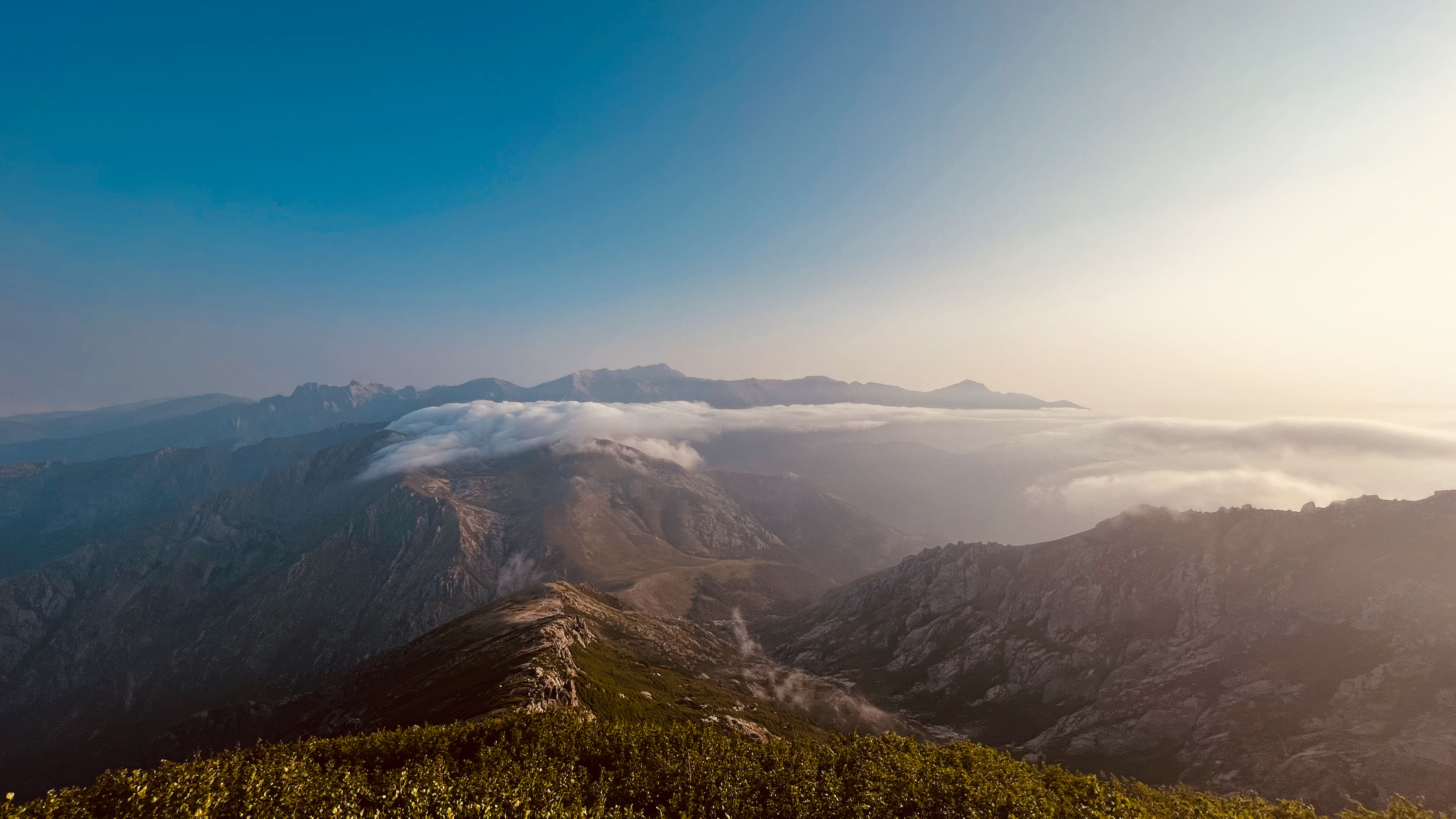
The French Grande Randonnée No. 20, better known as the GR20, is a "Great Hike" footpath that crosses the Mediterranean island of Corsica running from north to south, described as "one of the top trails in the world". The trail is considered to be the most difficult of all the GR routes in Europe, thanks to the loose rocks, snow and puddles, extreme heat and cold, or the climbing. The trail can demand over 3300 feet of vertical ascent in just 3 miles.
But, it is also the most rewarding trail: good views might come free in the great outdoors, but the best don't come without a bit of hard work.
| Distance | 129.98 mi |
|---|---|
| Elevation gain | 44,475 ft |
| Elevation loss | 44,549 ft |
| Time | 13 days |
About the trail
Between the northern starting point at Calenzana to the finish at Conca in the south, there are hidden mountain lakes, expansive sea views, rugged and rocky cliffs, and remarkable panoramas.
The northern part, between Calenzana and Vizzavona, is the more difficult part because of the steep and rocky paths while the southern part, between Vizzavona (the halfway point) and Conca, is (only slightly) easier with rolling hills and green as far as the eye can see. After the halfway point I began combining stages due to how easy the southern portion was.
This particular trail is one where camping is most common form of shelter at the various mountain huts, known as "Refuges", along the trail. Each of these Refuges provides basic services including home-cooked meals, bathrooms, and showers. The summer months of June and July are usually the best time to go since most of the refuges are opened and staffed.
A highly recommend resouce to have for planning this hike is the Cicerone guidebook.
Getting there
Corsica has four airports, believe it or not: two in the north and two in the south. All are potentially fine options for getting to the start/end of the trail, and I went with Calvi just because plane schedules worked out that way. At the end of the hike I flew out of Ajaccio.
Where to sleep each night
There were three options on this trek:
- Book a bed in a dormitory (where available)
- Book one of the many provided tents
- Bring your own tent
Luckily for this thru-hike you don't need to book anything in advance when bringing your own tent: all you have to do when showing up at a Refuge is tell the guardian that you've got your own tent, and they'll tell you to pitch it wherever you can find an open spot.
All of the Refuges had plenty of places for those who brought their own tents, but they also had plenty of their own heavy-duty tents that could be reserved in advance or when you showed up (if they have any available that is). Some even have dormitories available for reserving in advance, but tents are the main way to go on this hike.
Each refuge has showers and bathroom facilities as well.
Some of the tent sites are exposed to the wind, while others had rock walls or vegetation encircling them. A fair amount of spots also had ground that was too hard for stakes, but plenty of heavy rocks were nearby. Most of the spots I pitched my tent at were partially exposed to the wind, and only a few of them had partial shade.
Food and meals
Perhaps one of the best comforts of this hike is the luxury of the refuges which sell food and drinks and serve a pretty gourmet dinner, which is available at all refuges for 20-25 euros per person. You need to order dinner, and breakfast if you want it, on arrival though in order to guarantee a seat and a plate.
Other food options including snacks, sandwiches, breads, cheese, and charcuterie are available to purchase ahead of dinner time.
Now for the best part: beer and wine are available at all refuges for an affordable price. Wine is served by the glass, half a liter or full liter, and usually 2, 5, and 10, euros respectively. Beer was typically 7 euros for a 16oz glass and came cold.
If you do wish to bring your own meals, each Refuge has a place for cooking.
Gear requirements
It is highly recommended to go as light as possible with gear on this hike, even if this means shelling out cash for some ultralight gear. The time spent hiking over the mountainous terrain, or along narrow/steep ledges, is much more pleasant when carrying less weight on your back, and I can attest to that. My pack, before adding water and food, weighed about 10 pounds or 4.5 kg.
A full list of the gear used on this trek can be found here. Most of the gear worked out very well, but some items didn't, and I learned a lot about which ultralight items worked for me.
Here are some of the must haves for this trek:
- Solid, comfortable, footwear
- Trekking poles
- Lightweight pack (ideally 30-45 liters)
- At least two 1L waterbottles, with water filter
- Ultralight rain jacket
- Hat
- Fleece and puffy jacket
- Warm, but light, sleeping bag
- Ultralight pillow
- Sunscreen
- Camp shoes
- Enough cash for the entire trek
- Powerbank
Stages
Every thru-hike is different, and while some may necesitate the need to follow the guidebook stages, others require the need to be flexible. For this thru-hike some of the stages are by-the-book, while others are a combination of two or more:
- Day 01
Calenzana to Refuge D'Ortu Di U Piobbu
The adventure starts with the Mediterranean nearby, and the trail sets off on a gentle climb, slowly making its way into the mountains.

View Route and read Trip ReportDistance 7.73 mi Elevation gain 4,849 ft Elevation loss 815 ft Time 5 h 38 m - Day 02
Refuge D'Ortu Di U Piobbu to Refuge de Carozzu
Only six miles. Easy, right? Of course not. It took hours to navigate the mixture of woodland and open mountain, all while climbing up to a beautiful viewpoint looking down on the valley below.

View Route and read Trip ReportDistance 6.3 mi Elevation gain 2,882 ft Elevation loss 3,780 ft Time 6 h 42 m - Day 03
Refuge de Carozzu to Ascu Stagnu
Short distances do not mean quick days on the GR20. The 4.5 miles on this day were not easy, climbing almost immediately after leaving the Refuge.

View Route and read Trip ReportDistance 4.74 mi Elevation gain 2,939 ft Elevation loss 2,419 ft Time 5 h 29 m - Day 04
Ascu Stagnu to Auberge U Vallone
The pass and climb of the highest point on the island lies ahead. The route involved rocky trails and a bit of scrambling on either side of the peak, but it's all about that view out over the mountains and the island of Corsica.

View Route and read Trip ReportDistance 7.95 mi Elevation gain 4,105 ft Elevation loss 4,064 ft Time 8 h 21 m - Day 05
Auberge U Vallone to Hotel Castel di Vergio
Gentle forest paths and alpine-style pastures quickly lead back up to the rocky mountains before making a U-turn at the top and heading back downhill for the rest of the day, with the Mediterranean Sea on the right.

View Route and read Trip ReportDistance 9.72 mi Elevation gain 3,071 ft Elevation loss 3,098 ft Time 6 h 8 m - Day 06
Hotel Castel di Vergio to Refuge de Manganu
This is one of the most varied and perhaps one of the most beautiful days on the GR20. It was also a bit easier than the previous days, traveling over green meadows and reaching a beautiful mountain lake.

View Route and read Trip ReportDistance 11.16 mi Elevation gain 2,202 ft Elevation loss 1,547 ft Time 6 h 38 m - Day 07
Refuge de Manganu to Refuge de Petra Piana
After a relatively simple stage, it's back to ascending and carefully navigating mountain ridges. But there are some serious views, with twin lakes below and ice fields to cool aching feet.

View Route and read Trip ReportDistance 6.72 mi Elevation gain 3,031 ft Elevation loss 2,147 ft Time 6 h 25 m - Day 08
Refuge de Petra Piana to Refuge de l'Onda
Nearly downhill for the entire stage, steep at first, but then over wide trails through forests, along rivers, and passed a waterfall, before starting the gradual climb up to the Refuge.

View Route and read Trip ReportDistance 6.87 mi Elevation gain 1,537 ft Elevation loss 3,022 ft Time 4 h 20 m - Day 09
Refuge de l'Onda to Vizzavona
One of the best mornings on the GR20. The hike up from l'Onda is slow going at first, but the views from the ridge were among the best on the hike, especially with the amazing cloud inversion, before toppling over to the other side of the mountains, and the halfway point.

View Route and read Trip ReportDistance 7.68 mi Elevation gain 2,471 ft Elevation loss 4,008 ft Time 4 h 49 m - Day 10
Vizzavona to Bocca di Verdi
From Vizzavona it was time to start combining stages, over well-graded trails, and pleasant switchbacks, heading back into the somewhat gentler mountains of the southern half, and then down over pleasant hillsides.

View Route and read Trip ReportDistance 17.4 mi Elevation gain 4,857 ft Elevation loss 3,690 ft Time 7 h 15 m - Day 11
Bocca di Verdi to Refuge d'Usciolu
This stage was difficult, and exposed in many areas (especially with the low clouds obscuring the trail ahead), but a truly magnificent, long ridge walk with a series of summits.

View Route and read Trip ReportDistance 10.94 mi Elevation gain 4,969 ft Elevation loss 3,545 ft Time 7 h 5 m - Day 12
Refuge d'Usciolu to Refuge d'Asinau
The morning was spent walking through an unexpectedly lovely, and lush, plateau, full of green as far as the eye could see. But the trail turns towards the ascent once more, before dropping down to the Refuge.

View Route and read Trip ReportDistance 13.88 mi Elevation gain 3,809 ft Elevation loss 4,453 ft Time 7 h 2 m - Day 13
Refuge d'Asinau to Conca
This is it, the last stage, and it started with a pleasant descent to the valley below before flanking the mountainside along a river through pine forests, and once again ascending up and over a col to a long ridge hike towards the gateway at the end.

View Route and read Trip ReportDistance 18.89 mi Elevation gain 3,753 ft Elevation loss 7,961 ft Time 9 h 19 m
My thoughts and opinions
I went during the summer months of June and July because summer is usually the best time to go since most of the refuges are opened and staffed. I didn't book anything in advance since I was camping the whole way, I simply showed up at a refuge, said I had a tent, and pitched it wherever there was an open spot.
Since it was a show-up-and-go kind of hike, I could easily pick and choose where I wanted to stay. I mostly followed the guidebook, especially since this turned out to be a very tough thru-hike due to the mountainous terrain. I can't stress enough how valuable the guidebook is on this trail.
On this particular trek I wanted to go as light as possible in order to have a more pleasant time, so I had to look at every piece of gear I currently owned and see where I could drop the ounces. This was my first time with ultralight gear, and I learned a lot about what worked for me, and what didn't work.
The tent worked for the most part, but you had to get the setup and pitch just right in order for it to work, and most of the ground was too hard for stakes, which meant the wind would win every now and then.
For my camp shoes I had originally purchased a set of mayfly's which are paper thin and weigh practically nothing. Great if you want to go ultralight like I did on this trip, but they were a bad idea as they provided zero protection from the rocky ground at campsites. I quickly swapped those out for a thicker pair of flipflops from a shop at one of the Refuges.
A tiny towel was also a bad idea. It didn't have enough surface area for absorbing all the water off of my body after a shower. But it did dry really quickly.
This was the last thru-hike on my list of places that I had first discovered back in 2018. It was said to be the hardest of them all, but I thought "hey, I've done the Himalays and survived, I can do anything". Boy was I wrong, this was definitely the hardest thru-hike I have ever done. But, it was also one of the most rewarding because it allowed me to cement what I liked and didn't like about thru-hiking, and how I would do future hikes.
After the halfway point I began combining stages due to how easy the southern portion was, and I was eager to get to the hotels I had booked in two different cities so that I could actually explore the place I was thru-hiking in for once!
It had its ups and downs, but overall the GR20 was a great experience. I even formed a group of friends on the first day and we hiked together all the way to Vizzavona, the halfway point.
I highly recommend this trek for those who are looking for a challenge and amazing views, with the promise of a beach vacation at the beginning and/or end of the trek.